
Numeracy Intermediate November 2016 Unit 1 Q4
4. The map shows a part of Wales.
The position of Newtown is shown on the map.
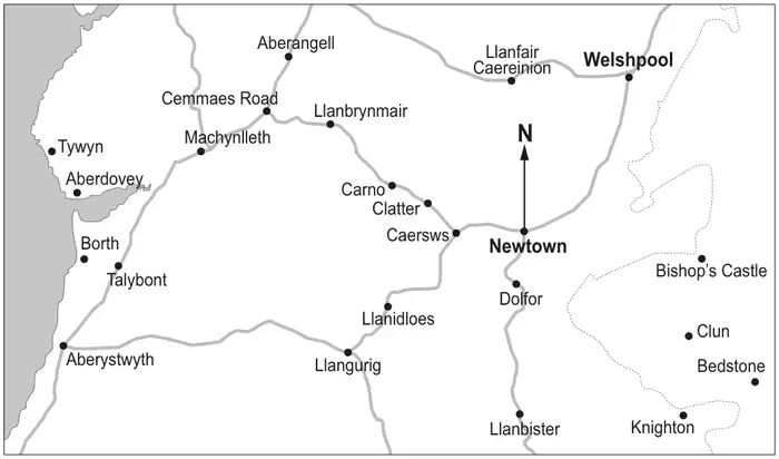
(a) Write down the bearing of Welshpool from Newtown. [1]
…………… °
(b) Name the place on the map that is on a bearing of 235° from Newtown. [2]
(c) The distance from Newtown to Welshpool is approximately 14 miles by road.
(i) Estimate the distance by road from Welshpool to Llanfair Caereinion in miles. [1]
…………… miles
(ii) Megan lives in Cemmaes Road.
To travel to work, she starts by heading towards Machynlleth.
Her journey to work is approximately 40 km.
To travel to work, she starts by heading towards Machynlleth.
Her journey to work is approximately 40 km.
Convert 40 km to miles. [2]
…………… miles
In which town or village could Megan work? [1]
(d) A different map has a scale of 1 : 10 000.
Megan measures 3 cm on this map.
What distance does this represent in metres? [2]
Megan measures 3 cm on this map.
What distance does this represent in metres? [2]
…………… metres
| Scheme | Marks | Comments |
|---|---|---|
| 034° ± 2° | B1 | Do not accept 34° ± 2° Allow N34°E ± 2° |
| Scheme | Marks | Comments |
|---|---|---|
| Llangurig | B2 | B1 for an answer of Llanidloes |
| Scheme | Marks | Comments |
|---|---|---|
| (i) An answer in the range 8 to 11 miles inclusive | B1 | |
| (ii) 5 × 40 ÷ 8 | M1 | Accept evidence of 40 ÷ 1.6 For this question accept use of 3 miles is approximately 5km, with an equivalent calculation 3 × 8 |
| 25 miles | A1 | For this question FT from 3 miles is approximately 5km to give an answer of 24(miles) Accept unsupported answers of 24(km) and 25(km) |
| Aberystwyth | A1 | Unsupported answer of Aberystwyth is M0, A0, A0 It is possible to award the final A1 from M1, A0, but not from M0 |
Corrected by Westie's Workshop
- The board's mark scheme printed “Unsupported answer of Aberyswyth”. Changed to “Unsupported answer of Aberystwyth” because the town is spelled Aberystwyth, as in the answer column.
Original: see the board's mark scheme PDF (link above).
| Scheme | Marks | Comments |
|---|---|---|
| 3 cm represents 30 000 cm or 3 : 30 000 or sight of 3×100 | M1 | Allow sight of (3cm is) 30000 |
| 300 (m) | A1 | An answer of 30 000 is awarded M1, A0 |