
Numeracy Foundation November 2019 Unit 2 Q9
9. A map of north Wales and the border with England is shown below.
The distance between Wrexham and Oswestry is approximately 22 km by road.
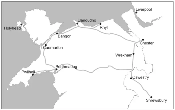
(a) The straight-line distance between Wrexham and Oswestry on the map is 2·2 cm.
Which of the following represents the scale of the map?
Circle your answer. [1]
Which of the following represents the scale of the map?
Circle your answer. [1]
1 : 10 1 : 1000 1 : 10 000 1 : 100 000 1 : 1 000 000
(b) Lauren travels by road directly from Wrexham to Oswestry.
This journey takes 25 minutes.
Calculate the average speed for Lauren’s journey.
Give your answer in km/h. [3]
This journey takes 25 minutes.
Calculate the average speed for Lauren’s journey.
Give your answer in km/h. [3]
Average speed …………………… km/h
| Scheme | Marks | Comments |
|---|---|---|
| 1 : 1 000 000 | B1 |
| Scheme | Marks | Comments |
|---|---|---|
| (Average speed in km/h =) \(\dfrac{22}{25/60}\) or \(\dfrac{22}{25}\) × 60 or \(\dfrac{22}{25 \div 60}\) | M2 | Allow M2 for sight of correct method, including premature approximation (e.g. using 25/60 = 0.4(166...) M1 for any one of:
|
| 52.7 (km/h) to 53 (km/h) | A1 | Treat use of 2.2 instead of 22 as MR-1 on accuracy mark only |