
Numeracy Foundation November 2023 Unit 1 Q9
9. The map below shows part of South West Wales.
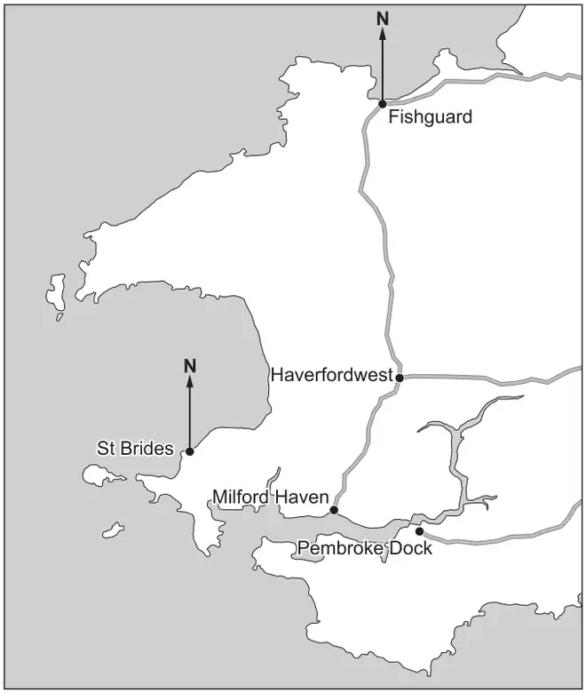
On screen this diagram may not be shown at actual size. To measure it, use the question paper (PDF) printed at 100%.
(a)
Find the bearing of St Brides from Fishguard. [1]
…………………… °
(b)
The distance by road from Haverfordwest to Milford Haven is 12 km.
(i)
Estimate the distance by road from Haverfordwest to Fishguard. [1]
…………………… km
(ii)
Owain has a different map that has a scale of 1 : 25 000.
Owain measures the distance by road from Haverfordwest to Milford Haven on his map.
Complete Owain’s statement below.
“On my map, the distance by road from Haverfordwest to Milford Haven is represented by a length of …………………… cm.” [3]
| Scheme | Marks | Comments |
|---|---|---|
| 209° ± 2° | B1 | Answer space takes precedence |
| Scheme | Marks | Comments |
|---|---|---|
| (i) Answer in the range 21 (km) to 25 (km) | B1 | Answer space takes precedence |
| (ii) Correct interpretation of the map scale, e.g.
Correct conversion 12 km to cm, 25 000 cm to km or equivalent, e.g.
| B1 | |
| 12 ÷ 0.25 or 12 × 4 or 1 200 000 ÷ 25 000 or 1 200 ÷ 25 or equivalent | M1 | Ignore place value error, e.g. 12 ÷ ‘their number with digits 25’, 12 × ‘their number with digit 4’ |
| 48 (cm) | A1 | CAO |
9(b)(ii) Alternative method
| Scheme | Marks | Comments |
|---|---|---|
| (Original map scale is 3 cm : 12 km =) 3 : 1 200 000 or 1 : 400 000 or equivalent | B1 | |
| \(\dfrac{400\,000}{25\,000}\) × 3 or 16 × 3 or equivalent | M1 | Ignore errors in place value |
| 48 (cm) | A1 | CAO |