
Foundation June 2025 Paper 2 Q4
4. The grid below shows the map of a park.
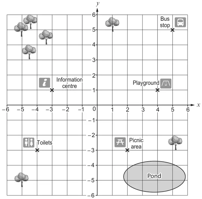
On screen this diagram may not be shown at actual size. To measure it, use the question paper (PDF) printed at 100%.
(a) Write down the coordinates of the playground. [1]
(b) There is a climbing wall at the midpoint between the bus stop and the information centre.
Mark with a cross (×) the position of the climbing wall on the map. [1]
Mark with a cross (×) the position of the climbing wall on the map. [1]
(c)
The scale on the map is:
| 1 cm represents 45 m |
Caelan walks directly from the picnic area to the toilets in a straight line.
He walks back to the picnic area along the same straight line.
How far did Caelan walk altogether?
Give your answer in metres. [2]
| Scheme | Marks | Comments |
|---|---|---|
| (4, 1) | B1 |
| Scheme | Marks | Comments |
|---|---|---|
| An unambiguous cross marked at (1,3) | B1 |
| Scheme | Marks | Comments |
|---|---|---|
| 540 (m) | B2 | Allow answers in the range 522 to 558 from use of 6 ± 2mm B1 for one of the following:
|
| (4) |