
D1 January 2011 Q1
1.
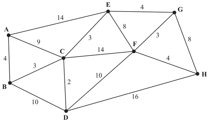
Figure 1 shows a network of roads between eight villages, A, B, C, D, E, F, G and H. The number on each arc gives the length, in miles, of the corresponding road.
| Scheme | Marks |
|---|---|
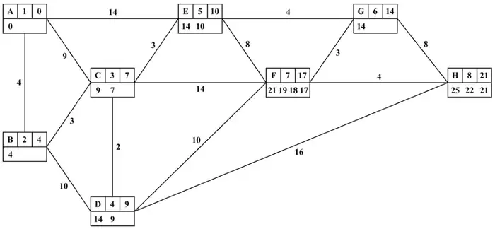 | M1 A1 A1ft A1 |
| The length of the shortest route is 21 miles | A1ft |
| (5) |
Notes
1M1: Smaller number replacing larger number in the working values at C or D or G or E or F or H. (generous – give bod)
1A1: All values in boxes A, B and C correct. (Condone missing wv at A) (Allow order of labelling starting at 0)
2A1ft: All values in boxes D, E and G (ft) correct . Penalise order of labelling errors just once, G must be labelled before F.
3A1: All values in boxes F and H correct
4A1ft: Follow through from their H value, condone lack of units here.
| Scheme | Marks |
|---|---|
| Shortest route: A B C E G F H | B1 |
| (1) |
Notes
1B1: CAO (either way round)
| Scheme | Marks |
|---|---|
| Shortest route: H F G E C | B1ft |
| Length of shortest route: 21 – 7 = 14 miles | B1ft |
| (2) | |
| (8 marks) |
Notes
1B1ft: only ft if their shortest route goes through C, in which case accept their route reversed up to C (either way round)
2B1ft: only ft if their shortest route goes through C, in which case accept their route length (or final value at H) -7.